After a heavy shower, a neighborhood can have water on its roads while its water-supply system still depends on deep groundwater. Diabari makes that apparent contradiction easy to understand. Rainwater needs space to collect and a connected route to leave. Solid waste can interrupt that route at several points.
I brought together my review of water management, solid waste, and local mapping to ask a practical question. What would keep the same drain from blocking again after it has been cleaned?
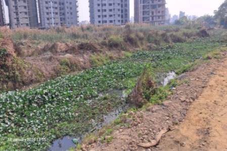
Follow the water and the waste together
Runoff moves from roofs and streets to small drains, canals, lowlands, and eventually a receiving river or pumping system. A local blockage may be visible, but water can also be held back by a raised road, a disconnected canal, a high downstream water level, or inadequate storage. Clearing one inlet cannot recover a filled wetland.
Waste follows its own connected route. Household separation, storage, collection, transfer, recovery, and final disposal all matter. If collection is irregular or a transfer point is full, the canal may become the unofficial alternative. Drain cleaning and waste collection therefore need one operating schedule.
A neighborhood plan with clear responsibilities
| Action | What it changes | What to check |
|---|---|---|
| Protect lowlands and canal connections | Retains rainfall storage and a route for runoff | Map the inlet, outlet, crossings, and ownership before work |
| Collect and separate waste consistently | Keeps organics and plastics out of drains | Track missed collections and repeated dumping points |
| Clear drains and remove the recovered material | Restores conveyance without moving the blockage downstream | Record where the waste and silt actually go |
| Separate organics and dry recyclables | Makes composting and material recovery more workable | Confirm segregation, odor control, and a real outlet for products |
| Capture roof rainwater for suitable uses | Reduces some runoff and demand for supplied water | Match storage to demand and provide a managed overflow |
Start with one problem route
Choose a frequently flooded street and trace its drainage route during safe conditions. Mark each inlet, culvert, canal connection, and repeated dumping point. Ask residents where water first appears, how long it remains, and whether the pattern changes when the river is high. Record the rain date and the time of each observation.
Then assign a named team to collection, blockage removal, and disposal. Repeat the same photographs after cleaning and after a comparable rain. A shorter ponding duration is more informative than the number of truckloads removed. Comparing storms still needs rainfall and downstream-level context.
Use recovery facilities where the collection system can support them
A materials recovery facility (MRF) sorts recoverable materials. A small neighborhood facility can help when dry recyclables arrive separately and buyers can take them. Organics need their own controlled process. Residual waste still needs an approved disposal route. A shed labeled “recycling” cannot solve mixed-waste collection by itself.
For rainwater harvesting, start with a useful demand such as cleaning or another suitable non-potable use. Design the first-flush arrangement, screening, covered storage, access for cleaning, and overflow together. Groundwater recharge needs a separate assessment of soil, water quality, and groundwater conditions.
What the maps can tell us
The source materials combine local photographs with historical imagery and published work on northern Dhaka. They help identify places where development and drainage pressure coincide. A water or built-up index alone cannot identify the cause of an individual blockage. Site levels, outfalls, rainfall, and maintenance records complete the picture.
My practical priority
Protect the remaining water pathways, then connect regular waste collection to drainage maintenance. I would judge success by fewer repeat blockages, shorter waterlogging, and a reliable disposal record. These are desk-review recommendations that can be tested on a small route before expanding across a neighborhood.
Read the supporting evidence
Sakib and colleagues’ 2023 study of urbanization and pluvial flooding in northern Dhaka explains why land use and drainage must be considered together. My source review also draws on Kabir (2015) on municipal solid waste and the Diabari Neighborhood Community’s 2026 records.
Continue reading
Diabari Wetlands, Drainage and Habitat Protection · Turag River Environmental Flow and Seasonal Change
Leave a Reply